Capidava Fortress
The history of Dobrogea was largely determined by its geographical position, at a crossroads. The main routes crossing Dobrogea are the sea route, the Danube route and the road that runs through the center of this territory, from north to south. Although the Romans had reached the Danube as early as 14 AD, it was only during the reign of Emperor Domitian that Dobrogea was included in the strategic plans of the Empire, with Scythia Minor becoming the base for expeditions across the Danube against the Dacians.
The history of Dobrogea was largely determined by its geographical position, at a crossroads. The main routes crossing Dobrogea are the sea route, the Danube route and the road that runs through the center of this territory, from north to south. Although the Romans had reached the Danube as early as 14 AD, it was only during the reign of Emperor Domitian that Dobrogea was included in the strategic plans of the Empire, with Scythia Minor becoming the base for expeditions across the Danube against the Dacians.
Trajan, however, is the one who manages to organize the Scythian limes sustainably, building camps and castles on the right bank of the Danube and at crossing points, as is the case with the Capidava fortress. With rare exceptions, the Scythian limes thus organized ensured peace in the province for more than a century.
The fortification is located at an equal distance – 18,000 paces (i.e. 27 km) – from Axiopolis (Hinog Hill, near Cernavodă) to the south and from Carsium (Hârșova) to the north, on the edge of the village that bears the ancient name of the place again. In the Ottoman era, a border village is recorded here which implicitly testifies to the existence of visible ruins (Kalakioi).
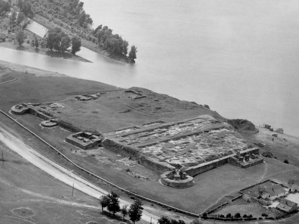
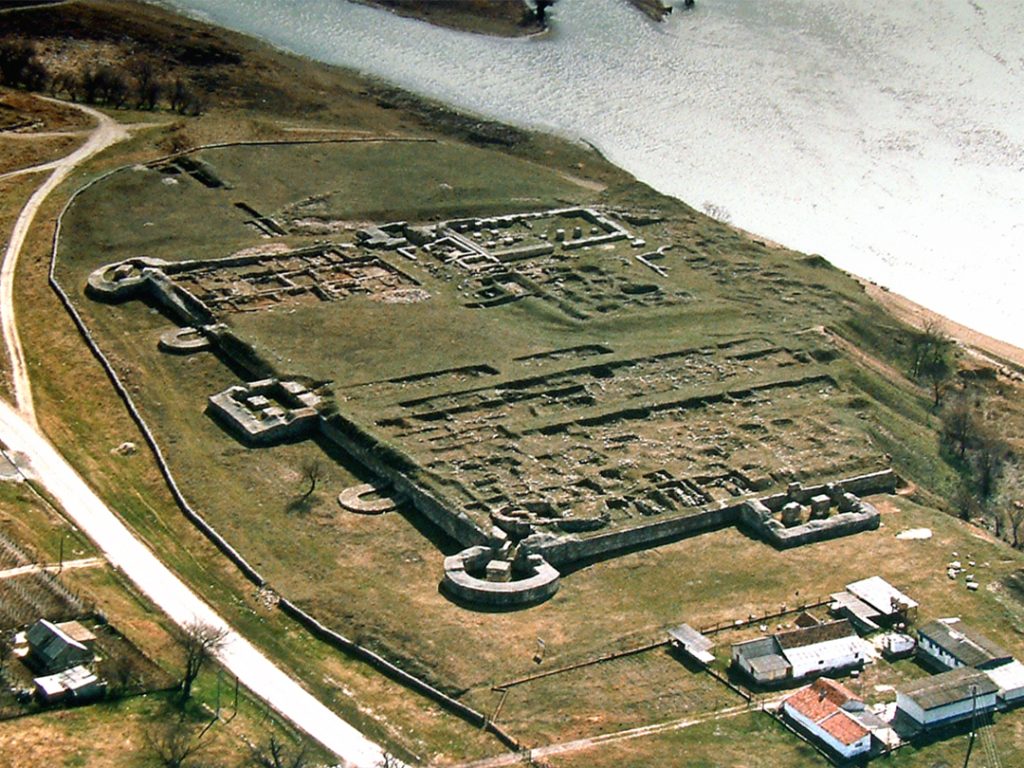
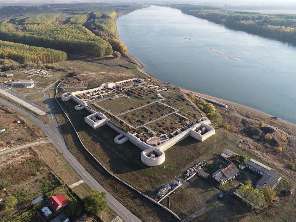
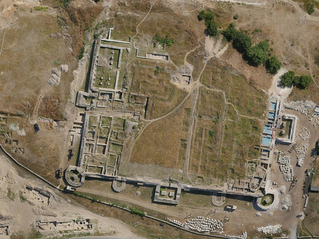
The fortification has the shape of a quadrilateral with long sides from NW to SE - 105 m x 127 m, with walls over 2 m thick and 5-6 m high, with 7 towers over 10 m, of which 3 rectangular towers, 2 quarter-circle towers and 2 intermediate horseshoe-shaped (U) towers, a 2.50 m wide gate located on the SE side that connected with the rest of the territory and a strategic exit on the SW side of the tower from the Danube, where the port was arranged.
The fortress occupied an important place in the Roman defensive system, being part of the series of camps and fortifications built during the reign of Emperor Trajan, at the beginning of the 2nd century, as part of the measures to organize the Danube limes. The location was particularly suitable for the character of the construction, offering a vast surveillance area: a rocky massif rising between the foot of the slope descending from the NE and the Danube. The massif presented a strategic advantage, namely a natural ditch that started from the Danube, bypassed it on the NE side, almost to the eastern corner of the fortress. In fact, the shape of the massif imposed the shape and orientation of the camp.
The strategic importance of the place determined the installation of a military station as well as the location and development of a civil center in the Roman era. The castrum, located near a ford, was built by detachments from the V Macedonica Legion and the XI Claudia Legion. The Tabula Peutingeriana provides us with accurate data on the distances between Axiopolis, Capidava and Carsium. These distances coincide with the distances between the current localities of Hinog – Capidava and Capidava – Hârșova. When verifying the table, a military pillar was discovered in the locality of Seimenii Mici which gives the distance of 18,000 paces from Axiopolis to Capidava, i.e. 27 km.
The original Getic toponym confirms not only the existence, but also the significance of the pre-Roman habitation. Without having been identified in the field and possibly razed to the ground by the very construction of the first Roman camp, the Getic Capidava would have enjoyed a privileged strategic position, playing an important role in the contacts between the Dobrogean Getae and those from the Muntean Plain. Here Vasile Pârvan located the headquarters of the unfortunate Dobrogean dynast Dapyx, a local leader who disappeared in the confrontations of 28 BC with the proconsul of Macedonia – Marcus Licinius Crassus, about whom Cassius Dio tells us in Roman History, LI, 26, 1-4.
The Trajan-era castrum was also equipped with a port facility, warehouses and other annexes on the upper terraces, with terme – public baths – outside the enclosure walls, to the southeast. The latter served first the military, but also the civilian population that lived around the fortress or in its territory. The dual role, military and commercial, of Capidava is also evident from the epigraphic mentions of a conductor, and then of a procurator who were in charge of or even functioned next to the customs office in the fortress statio per publicum portorium Illyrici. From here the troop quartered in the garrison, in collaboration with subunits of the Moesian fleet, controlled the river artery from a military point of view, as well as a large territory of the barbaricum.
Also at Capidava, a consular beneficiary is reported, a non-commissioned officer in charge of maintaining the strategic limes road and ensuring local public order. To the east and northeast of the fortress stretched the tumulus cemetery and further south, a flat cemetery, with more modest graves. Capidava of the Principate era (2nd-3rd centuries AD) represents the administrative headquarters of a vast and rich agricultural territorium of Dobrudja, a fact attested epigraphically by inscriptions that mention numerous vici (villages) and their magistri, approved divinities and wealthy owners of villae rusticae. Next to the strong local community in the civil settlement developed around the fort, made up of natives, veterans, Roman citizens, we find, especially during the 3rd century, a significant number of other Greco-Romans.
The original Trajanic fortification, probably repaired after the devastating raid of the Costoboci recorded by literary sources in 170, will be rebuilt from the foundations (a fundamentis) only in the second half of the following century, after the end of the terrible bellum Scythicum. The fortress had been, along with almost all the Dobruja cities, seriously affected by the Gothic attacks of the mid-3rd century. Based on some newer or older epigraphic monuments, it is assumed that the general reconstruction (phase II) is to be placed in the time of the emperors Aurelian or Probus (270-75, 276-282, respectively), perhaps extending into the era of the great administrative-military reforms and especially the reconstruction of the fortification system on the Danube in the time of Diocletian (284-305). With successive repairs during the following centuries (construction phases III-IV), occasioned by the destruction attributed to the Goths or Huns in the 4th-5th centuries AD, the new fortress would last until the beginning of the 7th century, the last coin discovered dating from the year 614.
The archaeological deposits subsequent to the IV construction phase – that is, the last Roman phase – are much later, after an interruption of two centuries, the habitation will resume in most of the former extent of the fortress. Thus, starting with the 9th century AD, Capidava is reintegrated into the Danubian defensive system, and the new hut dwelling, precarious compared to previous eras, will shelter the community of Byzantine stratiotai (border guards) until the 11th century. In the middle of the same century, the settlement is definitively abandoned. The existing hypotheses focus on two moments full of drama: the attack of the Pechenegs in 1046 or the great migration of the Uzis in 1064, ending almost a millennium of history in Capidava. During this period the walls of the fortress follow the route of the late Roman and Romano-Byzantine enclosure and constitute in fact a stone and earth elevation of poorer quality. The contour of the new fortress is doubled in this last phase by a defensive ditch whose traces can be found in the partial destruction of the towers of phases III-IV.
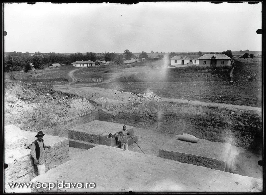
The ruins of Capidava have been known in folklore for a long time, the Turkish village founded in the 18th century – a military colony, bearing the name Kale-köy, meaning “the fortress village”. The first scientific explorers of the Dobrogean land, from the end of the 19th century and the beginning of the 20th century – captain Mihai Ionescu-Dobrogeanu and Grigore Tocilescu reported the fortification and collected antiquities from its area. In an archaeological expedition in the years immediately preceding the First World War, Vasile Pârvan identified it and had Pamfil Polonic draw up a brief situation plan of the ruins. Immediately after the war, Pârvan intended to implement a large archaeological research project in Dobrogea in which to involve all his students from Bucharest and Iași.
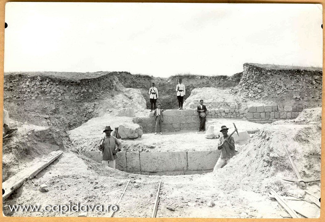
Archaeological research was initiated in 1924 by Grigore Florescu, Vasile Pârvan's assistant, who led the research at Capidava until the year of his death, 1960. Archaeological excavations were interrupted until 1965, when they were resumed by Radu Florescu with the support of the Dobrogea Archaeological Museum (today the Constanța Museum of National History and Archaeology) and have continued without interruption to the present day.
Conducted over the span of three generations, the research at Capidava is far from coming to an end. In the meantime, thanks to the remarkable discoveries, many of which are unique, Capidava has revealed its importance among the Danube fortifications of the Roman Empire, offering a typical example – in terms of military, administrative and ecclesiastical organization – of the transition from the early Roman Empire to its late phase, then to the Roman-Byzantine period and finally to the mid-Byzantine one.
The archaeological site at Capidava has played an important role in training future generations of archaeologists. It has operated since 1967 as a school site, initially receiving a smaller number of students, and then, starting in 1988, offering the possibility of significant participation in archaeological practice. Currently, students from four universities in the country are setting up their archaeology studies at Capidava: the University of Bucharest, the “Dimitrie Cantemir” Christian University of Bucharest, the “Ovidius” University of Constanța and the “Lucian Blaga” University of Sibiu.
Starting with 2015, a large-scale restoration, conservation and enhancement project of the monument was launched at the Capidava fortress. Today, the visiting circuit includes the thermal building, placed outside the fortress, the enclosure wall and the intermediate towers, the main gate located to the south, the military headquarters, the economic district, the basilica in the north-east corner, the secondary exit from the north as well as the port facility arranged on the Danube bank.
The Baths (2nd-3rd centuries AD): The baths were built outside the fortress, to the southeast, at the same time as the original Roman fortification, in the area known as sector X. The building material used, Roman brick, bears the stamps of the V Macedonica (LEG V MAC) and XI Claudia pia fiedelis (LEG XI C PF, or LEG XI CL) legions. Constructional restorations with changes in plan, including the transformation of a room with a hypocaust into a cold water basin (reservoir), are attested during the 2nd-3rd centuries, the last being from the Severic period, as attested by the stamps of the XI Claudia Ant(oniniana) legion. The existence of the ensemble ends towards the middle of the 3rd century AD, perhaps on the occasion of the great earthquake of 239 or following the Gothic attacks mentioned above.
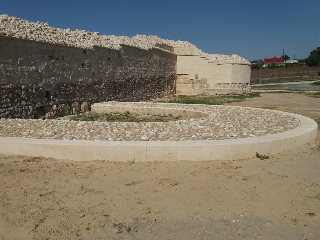
The enclosure wall and the intermediate towers: The wall appears robust and massive – 2-2.5 m wide – and never shorter than 2.50 m, in some sections reaching even 6 m in height. It is composed of eleven curtains and nine towers, which follow almost 5/8 of the perimeter of the fortress. The wall is built in opus cyclopaeum, with two facing sides between which a core – emplekton – was poured, consisting of irregular stones drowned in lime and sand mortar. At the curtains, the facings are made of quarry boulders – opus incertum; at the towers the outer facing is always made of large blocks, in some cases monuments – funerary but also inscriptions, fragments of statues or large blocks from monumental buildings – reused as building material, in hasty restorations. At the corners of the fortress, large quarter-circle towers, fan-shaped, with a massive central pillar on the inside, are symmetrically placed; the vaulted access corridors were made of brick and were archaeologically documented until the birth of the vaults. On the northeast side, between the corner towers and the central quadrangular one, the very low remains of two more intermediate towers (3 and 5), in the shape of a U (horseshoe), are still preserved; in 2015, a third similar tower (no. 9) was discovered, halfway through curtain G, in the immediate vicinity of the main southern gate. On the occasion of the first restoration of the enclosure wall – the beginning of the second late Roman phase – these small, horseshoe-shaped towers were abandoned and cut off at the level of the first assizes in the elevation.
The southern gate of the fortress, gate tower no. 7: A particularity of Capidava is the large gate flanked by a single tower on the right side. The opening of the only direct gate is 2.5 m, i.e. the ancient standard for the passage of a chariot, sufficient but also easier to defend. This gate leads the visitor to the interior of the fortification, being probably rearranged exactly on the site where the decuman gate of the original castrum had functioned. The unusual arrangement with a single tower flanking the gate is due to the special position of the fortification, defended on the outside by a triple ditch and which allowed access only from the ESE corner of the fortress. Inside the tower, traces of the first constructive phase of Capidava appeared, some remains of masonry belonging to a gate tower from the original castrum, at the base of the late Roman tower 7. The tower of the south gate at Capidava means three other towers and as many constructive phases of the gate in the 4th-6th centuries AD, more or less faithful to one and the same plan. Each phase of the three later ones is superimposed by the following ones on at least three of the four sides.
Tower no. 1 and the postern on its SW side: Located on the northwest side of the fortress, tower 1 has a small gate – postern – provided with an arched opening – of which only the birth of the arch has been archaeologically documented. This was closed with a solid wooden door, locked with a massive post that slid in a horizontal channel arranged in the thickness of the wall and was fixed in a recess in the opposite slat of the gate frame. Inside, the tower has two massive central pillars, symmetrical, which supported a truss floor. In the southeast wall of the tower, collinear with curtains A and B, the interruption of the masonry is distinguished, where access to the fortress was made, on a wooden staircase. Sometime in the 5th-6th centuries, the postern is blocked with a stone wall with earth, at a time when the tower is clogged on the inside, which raises questions about its functioning at this time. We know about the two quadrilateral towers of Capidava (of the phrourion type) that they housed artillery platforms with ballistae batteries on the upper part, which kept attackers at bay on the two sides on which they had been built. Such massive quadrilateral towers represent defensive elements specific to military architecture on the Lower Danube border, being known in Moesia Secunda and, especially, in the province of Scythia.
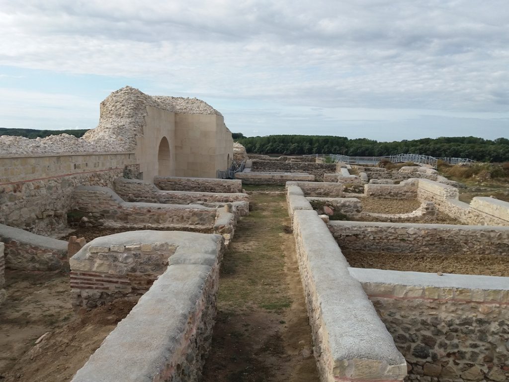
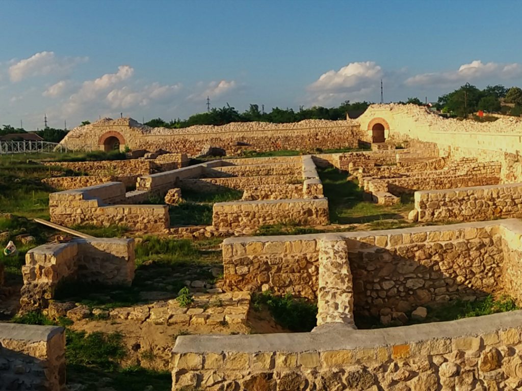
The “Guard House” in the southern sector of the fortress: The edifice represents, by its size and opening, the most imposing Roman construction in Capidava. Excavations that began in 1943 identified a basilica-plan building with three construction phases in the immediate vicinity of the main, southern gate of the fortress, attached to its H-curtain. Inside it, two rows of 7 pillars were identified, with the role of supporting the roof; another six pillars were attached to the enclosure wall. The portico was also equipped with masonry pillars, facilitating access to the main street of the fortress. In the first two phases of operation (4th century, 4th-5th century), the edifice was covered unitarily, with a massive frame, supported on the perimeter walls and on the pillars in the two inner rows, as well as on the pillars of the outer portico. At this stage, the function of the edifice was probably as a warehouse – horreum. The second phase also marks a partial restoration, when steps were also arranged for access to the guard road. The third constructive phase means the significant modification of the plan (6th century), by arranging an open inner courtyard, with the living space taking place only in the side naves. These are partitioned with light adobe walls, for living space, respectively storerooms. The function of the building seems to have been that of a warehouse and possibly barracks, for the use of the garrison of the limitana. Based on the numismatic material, it was possible to establish the cessation of the use of the building during the barbarian attacks in the last part of the 6th century, towards the end of the reign of Justin II (565-578 AD) or during the time of his successors, Tiberius II Constantine and Mauricius Tiberius.
Eastern sector: Resumed in 1975 and continuing to this day, the research led to the discovery of several rich constructions and remains of superimposed Roman barracks and partially used as foundations for buildings from the Roman-Byzantine period. These barracks (contubernia) took into account the existing street network planimetrically and were probably rectangular in shape with the sides parallel to the fortress's enclosure wall. The barracks present several distinct phases, the first wooden establishments being later replaced by more durable stone buildings, as a result of the efforts of the soldiers stationed here. The last phase, still visible today in its preserved form, is the largest and best documented. So far, two distinct buildings have been researched – E1 and E2 as well as a series of other annexed buildings. The construction technique used, opus mixtum, alternates stone foundations bound with mortar with brick belts. According to archaeological research, it was found that the upper part of the buildings had a gable roof, made of tiles joined with rafters, the entire structure being supported by solid wooden beams. The perimeter was arranged with pedestrian passage areas as well as with drainage and rainwater drainage installations, its evacuation being carried out through channels oriented towards the fortification's enclosure walls both to the east towards curtain F and to the south towards curtain G. The habitation ceased violently towards the end of the 6th century, everything being consumed in a strong fire, the traces of which can still be seen today on the perimeter walls of the curtains. A few centuries later, the arrangement of huts from the last phase of the fortress's existence affects the ruins of the burned buildings, the imprint of the semi-buried dwellings being preserved even today on the routes of the walls of the mentioned buildings.

The basilica in the northern corner of the fortress is the only Christian religious building discovered so far in Capidava. By its planimetric characteristics, the church dates from the first half of the 6th century AD and was directly inspired by the religious architecture of the Syro-Palestinian space. Its construction at the highest and at the same time most visible point in the entire fortress superimposes an older and more modest building in dimensions, built towards the end of the 4th century, possibly with the same purpose. To the NNW, another small construction was attached to it: a room - annex to the left of the altar which could constitute one of the two annexes specific to the liturgy in the East (diaconicon and prothesis), either with the function of a baptisterium. In the central area of the apse, in the altar, a small "crypt" or rather "place" for relics (lat. loculus, gr. enkainion) was identified, under the pavement, arranged from mortar and brick masonry. It reproduced the church plan on a reduced scale and probably housed the box with the relics of a martyr, according to the custom prevalent at the time, but it was emptied in antiquity.
The mid-Byzantine wall: From the 9th century AD, Capidava is reborn. The enclosure will be rebuilt perimeter and expanded after the Byzantines return to the Danube under John Tzimiskes. Capidava is reintegrated into the Danubian defensive system, and the new hut dwelling, precarious compared to previous eras, will shelter the community of Byzantine stratiotai (border guards) in the 11th century. In the middle of the same century, the settlement is definitively abandoned. Existing hypotheses focus on two moments full of drama: the Pecheneg attack in 1046 or the great migration of the Uzis in 1064, ending almost a millennium of history in Capidava. The walls of the fortress follow in the 11th century the route of the late Roman and Roman-Byzantine enclosure and in fact constitute a poor-quality stone and earth elevation of the Roman, durable ones, made of stone and mortar. To enhance the defensive effect, by briefly raising the stone wall, the outline of the new fortress is doubled in this last phase by a defensive ditch, traces of which can be found in the partial destruction of the towers of phases III-IV (towers 1, 2, 4, 6).
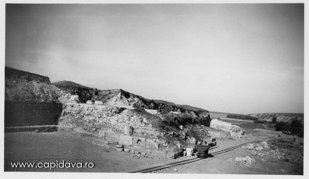
The fortress port: From the beginning, the fortress was equipped with its own port facility. It functioned in the Roman era until the 7th century and then under the Byzantines in the 10th-11th centuries. The facility included a low-water quay, warehouses and other annexes on the terrace immediately above. This simple quay, arranged parallel to the course of the Danube (oriented SE-NW) served the station of the military fleet classis Flavia Moesica with its main base at Noviodunum (Isaccea), being used, equally, for commercial purposes. The quay is in the form of a masonry bar with hydraulic mortar, over 51 m long and 2.5 m wide, parallel to the shore, the ends of which rest on two rock spurs. In antiquity, the wall was permanently bathed by the river water. The connection between the port and the fortress, which must have been made via a special gate located on the flank facing the Danube, is today irreparably destroyed; These dramatic events occurred recently, more precisely at the beginning of the 20th century. Then the entire western part of the fortress was literally blown up, during the industrial exploitation of the limestone massif that ensured its dominant position.
More than a century after the beginning of archaeological research in 1924, Capidava today represents one of the best-known, intensively researched and massively preserved fortresses of ancient Dobrudja. Along with Istros (Histria) – the old Milesian colony in the Left Pontus that lasted until the 7th century AD – or Tropaeum Traiani (Adamclisi), where Trajan achieved a resounding victory against the Dacians and their allies in the winter of 101-102, later building a city and a commemorative monument, Capidava can be considered, through its eminently military specificity, as the iconic fortress for the Dobrudja section of the Lower Danube limes. The scale of the curtains and the constructive details of the towers, the quasi-millenary stratigraphic succession (between the 2nd and 11th centuries), the thematic richness of the archaeological discoveries and, last but not least, the beauty of the place, hidden in a wooded bend of the river, argue for such a positioning.
Gallery


-

- File written by Adobe Photoshop¨ 5.0