The Hellenistic Fortress of ALBEȘTI
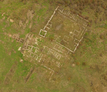
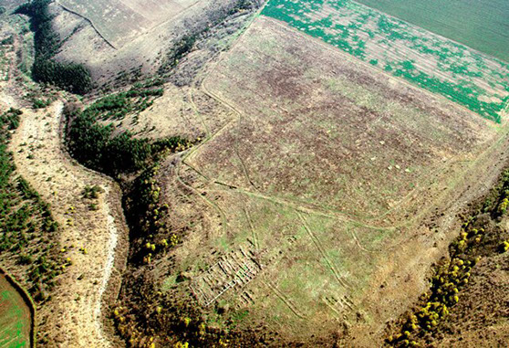
The fortified settlement of Albești is located in the Callatian territory, on its western border and on the line of a traffic artery that ensures the connection between the settlements in southeastern Dobrogea with those in the Danube area.
It falls into the category of permanent fortifications, designated by the term frurion, with a role in the defense and agricultural exploitation of the area. The proximity to Callatis, but especially the manner of construction of the enclosures, the quasi-urban character of the settlement, the preponderance of Greek materials support the idea of a Callatian creation. The other elements – Getic and possibly Scythian -, identified through inventory objects and forms of their own spiritual manifestations, give the measure of the Greek-indigenous character of the settlement.
The period of habitation of the site is placed between the 4th and 3rd centuries BC. The construction of the first enclosure, towards the middle of the 4th century BC, coincides with the action of organizing the territory and with the period of economic development of Callatida. The construction of the second enclosure may have been occasioned by the Macedonian actions at the end of the penultimate decade of the 4th century BC hostile to Callatida and by the desire of the same power to control the territory and commercial traffic in the area. The third enclosure marks an extension to the south and west of the fortified area, in accordance with the period of special economic development in the 3rd century BC.
The stages of the settlement's existence generally correspond to the three moments of construction of the enclosures. The first two stages are placed towards the middle and second half of the 4th century BC (possibly the end of the 4th century / the beginning of the 3rd century BC). The inhabited area, delimited by the first enclosures is approx. 1350 m2, respectively 1680 m2. In the third stage, the inhabited area is approx. 3200 m2 and exceeds the fortified space to the south and west. From a chronological point of view, this stage is placed in the 3rd century BC (after the first decades of the century) until the end of it or the beginning of the following century.
The economic decline at the end of the 3rd century / beginning of the 2nd century BC is highlighted by imported materials. In fact, the end of the 3rd century BC represents the moment when other settlements in Dobrogea ceased to exist. During this period, raids by the Bastarnae and the presence of the Scythians were recorded in Dobrogea (the latter attested in literary sources and recognized by material evidence, especially monetary evidence). It is possible that the establishment of Scythian "kingdoms" in the area, between Callatis and Dionysopolis, was a reason for the cessation of the functioning of the fortified settlement of Albești.
Material evidence from the Roman period was discovered to the south and west, beyond the fortress walls. At the current stage of research on the plateau and in the absence of such materials in the more intensively researched area inside the fortification, we cannot say whether this was a long-term Roman habitation, during the 1st-4th centuries AD, or just a temporary one during the aforementioned period.
Archaeological materials
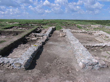
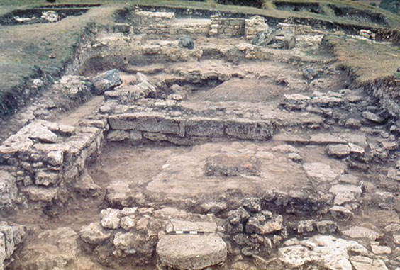
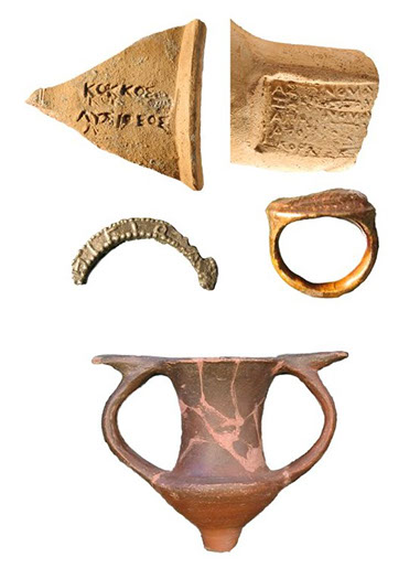
The archaeological inventory recovered is numerous and varied: containers and stamps, household vessels (imported or of local origin), ceramic statuettes and reliefs, bone or metal objects, coins, etc. The best represented category in terms of quantity is that of amphorae, originating from well-known production centers in the western Pontic area: Heraclea Pontica, Thasos, Sinope, Rhodes, Cnidus, Cos.
Common pottery consists, in order of frequency, of lekythoi, bowls, cups, platters, ointment jars and opaites. An important and well-individualized category is represented by the autochthonous pottery; it appears in forms and techniques that continue the older Hallstatt tradition and always together with pottery of Greek origin.
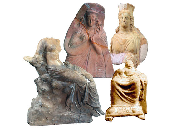
The figurative ceramic material – ceramic statuettes and sconces – proves to be particularly significant in the continuation of the spirituality of this rural settlement of the Hellenistic era. The representations belong, in order of frequency, to Cybele, Aphrodite, Demeter, Dionysus and Apollon.
The imported ceramic material (amphorae and amphora stamps) allows us to outline two peak periods of economic activities here: the first is placed towards the end of the 4th century and the first decades of the 3rd century BC; the other peak period will occupy the entire second half of the 3rd century BC and will surpass the first in scope and diversity. In fact, the 3rd century BC is best represented in terms of amphora imports, giving a measure of the economic development of the settlement during this period of its existence.
Collective of archaeologists
The archaeological research at Albești – the “Cetate” point was carried out from the beginning under the aegis of the Museum of National History and Archaeology Constanța (MINAC). The site was managed by Adrian Rădulescu (1974-2000), Maria Bărbulescu (2000-2003), Livia Buzoianu (since 2004). The initial team consisting of Adrian Rădulescu (site manager), Nicolae Cheluță-Georgescu and Maria Bărbulescu gradually expanded. Shortly after the start of the excavations, collaboration with the architect Anișoara Sion was established, and after about a decade, Livia Buzoianu also joined the team. We note the participation over the years of some colleagues from MINAC and the “Callatis” Museum in Mangalia: Traian Cliante, Lucian Arsenie, Valeriu Maxim, Laurențiu Cliante, Vitalie Bodolică. Constant presence on the site since his student years and later as a dedicated archaeologist and full member of the team was Nicolae Alexandru. His concerns regarding the Callatian territory happily correlated with the research of the Albești site. The current team is made up of Livia Buzoianu (responsible), Nicolae Alexandru, Irina Sodoleanu (Nastasi) and Marius Lascu – members and Maria Bărbulescu – scientific consultant.
text excerpt from the project INTERACTIVE VISUALIZATION ENVIRONMENT OF ANCIENT ROMAN CULTURAL HERITAGE FOR THE CROSS-BORDER AREA OF BULGARIA AND ROMANIA – (ARCHIVE)CODE 15.2.1.038INTERREG V – A ROMANIA – BULGARIA
The history of Dobrogea was largely determined by its geographical position, at a crossroads. The main routes crossing Dobrogea are the sea route, the Danube route, and the road that runs through the center of this territory, from north to south.
Although the Romans had reached the Danube since 14 AD, it was only during the reign of Emperor Domitian that Dobrogea was included in the Empire's strategic plans, with Scythia Minor becoming the base for expeditions across the Danube against the Dacians.
Trajan, however, is the one who manages to organize the Scythian limes sustainably, building camps and castles on the right bank of the Danube and at crossing points, as is the case with the Capidava fortress. With rare exceptions, the Scythian limes thus organized ensured peace in the province for more than a century.
The Capidava Fortress is located on the right bank of the Danube, halfway between Hârșova (Carsium) and Cernavodă (Axiopolis), and was built with the help of detachments of the V Macedonica Legions from Troesmis and XI Claudia from Durostorum, at the beginning of the 2nd century. Along with Capidava, from the fortification system built by Trajan on the Danube, we also mention Carsium (Hârșova), Cius, Troesmis, Noviodunum, Aegyssus.
The toponym of the fortress is Getic and translates as “settlement at the turn”, thus attesting, together with the archaeological evidence, a pre-Roman habitation in this strategically important place for contacts between the Getae of Dobrogea and those of the Romanian Plain. The toponym, which has been preserved exactly to this day, is attested both by ancient and later Byzantine sources, as well as by three inscriptions: the tombstone of C. Iulius Quadratus from the 2nd century, discovered at Ulmetum; a votive altar dedicated to the Thracian deity Hero by Aurelius Valens, also discovered at Ulmetum and dating from the end of the 3rd century – the beginning of the 4th century; the third is a fragmentary funerary inscription, recently discovered at Capidava and belonging to Aurelius … the military leader of the unit stationed in the fortification here.
The place chosen for the construction of the fortification is a particularly important one from a strategic point of view, being a rocky massif, surrounded on three sides by water (the Danube) and a natural ditch, which determined the installation of the military station and the development of a civilian center next to it. The shape of the rocky massif on which the fortress is located also imposed the quadrilateral plan of the fort.
The fortification for the auxiliary unit at Capidava (castellum) was probably built around the time of the two Dacian-Roman wars, with an offensive character. It was equipped with a port facility, a water quay, warehouses and other annexes, as well as the thermal baths outside the fortress walls. Also outside the fortress is attested the tumulus cemetery, with cremation graves, with rich inventories, but also a flat necropolis, with more modest funerary inventories.
Capidava, like the other fortresses located on the border, had to face numerous attacks by barbarian populations. Thus, the first Roman castrum was destroyed by the Carpo-Goths, probably following their invasion in 248, and was completely rebuilt towards the end of the 3rd century, with a purely defensive character. The ruins of the fortress that we still see today have, as we mentioned, a quadrangular plan, with sides of 105x127m, thick walls over 2m and 5-6m high, with seven towers, over 10m high (three rectangular towers, two in a quarter circle and two intermediate, in the shape of a horseshoe – the shape of the letter U). The fortress had a gate approximately 2.5m wide, located on the SE side, which connected with the rest of the territory, a strategic gate on the SW side of the tower towards the Danube and a port arranged in terraces towards the river.
Cetatea a suferit repetate distrugeri, până în secolul al V-lea fiind refăcută în două rânduri, ca urmare a numeroaselor atacuri ce s-au succedat pe parcursul a zeci de ani. În timpul celei de-a doua refaceri sunt incluse în ziduri și capiteluri, arhitrave, statui reprezentând diferite divinități, reliefuri de cult sau funerare. Acest lucru sugerează, pe de o parte, un nivel urbanistic ridicat dar, pe de altă parte, având în vedere faptul că piesele proveneau din așezarea civilă alăturată sau din necropolă, dovedesc urgența cu care s-au făcut reparațiile.
În secolul VI, după atacul devastator al hunilor ce a pârjolit cetatea, este probabil ca aceasta să nu mai dispus de suficiente fonduri pentru o reconstrucție. În această situație, a fost construit un mic fort patrulater (60x60m) în partea de sud a cetății.
În urma atacurilor avaro-slave, cetatea este complet distrusă și părăsită în secolul VII, inclusiv de către ultimele corpuri de trupe rămase să supravegheze zona.
În secolul IX are loc reorganizarea granițelor Imperiului Bizantin, iar Capidava, prin poziția sa, își găsește loc în strategia de organizare a noului sistem defensiv. Așadar, peste ruinele fortificației romane, se ridică o cetate țărănească de stratiotai (țărani-grăniceri), care durează până la jumătatea secolului al XI-lea, având și ea parte de refaceri succesive. Cetatea era înconjurată de un zid de piatră cu pământ ce urma traseul incintei romano-bizantine, dublat de un șanț de apărare.
Fiind o stațiune militară, aici au fost cantonate de-a lungul timpului o serie de corpuri de trupă, atestate epigrafic. Este vorba prima dată de cohors I Ubiorum (unitate auxiliară din Germania inferior), staționată aici de la înființarea castrului și până prin 143. A urmat cohors I Germanorum, o altă unitate de germani, staționată în cursul secolului al II-lea și probabil al III-lea p.Chr. Mai târziu, în epoca romano-bizantină (secolele IV-VII), sunt atestate o vexillatio Capidavensis (un detașament al Legiunii II Herculia), cuneus equitum Solensium și cuneus equitum scutariorum.
În circuitul de vizitare sunt cuprinse zidul de incintă, turnurile intermediare în formă de potcoavă, poarta cetății străjuită de turn. Urmează băile publice (termele), care au fost construite în afara zidurilor de incintă ale primului castru, pentru a deservi unitatea de auxiliari staționată aici. Au fost identificate mai multe încăperi cu hipocaust, bazine cu apă rece și piscine și canalul de evacuare al apei.
Basilica, singura descoperită până în prezent, are trei nave, despărțite prin două șiruri de pilaștri și se încheie cu o absidă semicirculară. Basilica datează din prima jumătate a secolului al VI-lea și prezintă influențe ale arhitecturii religioase syro-palestiniene. Ea a fost suprapusă unei basilici mai mici, construită spre sfârșitul secolului al IV-lea. În secolul al VI-lea, la Capidava funcționa unul dintre centrele episcopale ale provinciei Scythia, poziția strategică a Capidavei în zonă înlesnind, probabil, răspândirea creștinismului.
Cele mai recente campanii de săpături au scos la iveală un nou turn, care însă nu poate fi vizitat, fiind în conservare. În anul 2015 au fost efectuate cercetări extramuros și în zona portului, iar în 2017 se preconizează finalizarea cercetărilor la terme.
Locuințele ce datează din perioada medievală timpurie au fost cercetate pe o suprafață mare din cetate. Ele prezintă mai multe niveluri de locuire, ca urmare a refacerilor succesive. O piesă deosebit de importantă pentru istoria locală este un ulcior care datează din secolul X și poartă inscripția cu litere grecești a numelui românesc “Petre”. Această piesă, alături de altele din aceeași perioadă, ilustrează faza de desăvârșire a poporului român.
Știri despre existența unei cetăți aici aflăm încă din perioada modernă, numele satului turcesc întemeiat în secolul XVIII, purtând numele de “Kale-köy” (satul cetății). Fortificația este menționată și la sfârșitul secolului al XIX – începutul secolului XX de către Mihai Ionescu-Dobrogeanu și Grigore Tocilescu. Vasile Pârvan are ideea unui proiect de cercetare arheologică în întreaga Dobroge, la care urmau sa ia parte elevii săi.
Archaeological research was initiated in 1924 by Grigore Florescu, Vasile Pârvan's assistant, who led the research at Capidava until the year of his death, 1960. Archaeological excavations were interrupted until 1965, when they were resumed by Radu Florescu with the support of the Dobrogea Archaeological Museum (today the Constanța Museum of National History and Archaeology) and have continued without interruption to the present day.
Șantierul arheologic de la Capidava a avut un rol important în formarea viitoarelor generații de arheologi. El a funcționat încă din 1967 ca un șantier-școală, primind inițial un număr mai redus de studenți, iar apoi, începând cu 1988, au fost creeate condițiile unei participări semnificative în practica arheologică. În prezent, la Capidava își pun bazele în arheologie studenți de la patru universități din țară: Universitatea București, Universitatea creștină “Dimitrie Cantemir” din București, Universitatea “Ovidius” Constanța și Universitatea “Lucian Blaga” din Sibiu.